
Page 27 - mmopaMJ21
P. 27
which, if the weather is good, provides a thin slice of vertical airspace, at least during the week.
The China Lake Restricted Area, R2505, is continuous, starts at the surface, and has no upper limit. It creates a very narrow airspace channel between it and the Domeland Wilderness area, along Highway 395.
The planning takes him northeast over the largest wind farm in the United States then a slight northerly turn to near Inyokern (KIYK) and NNW up the Owens Valley river toward Bishop. All this helps explain the route planning.
Mammoth Lakes airport presents its own challenges at 7,135 feet MSL. It is located north of the Red Slate Mountains, which is an east/west ridge with peaks in the 12-13,000-foot range.
perpendicular wind direction relative to his course may have masked its effect on ground speed. I also recall some tribal knowledge that recommends crossing a ridge at least 1,000 feet above the ridge for every 10 kts or 6,500 feet for 65 kts. The pilot’s certifications, weather conditions, and potential icing scenario would have prevented a higher altitude in this case.
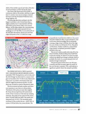
The aircraft climbs steadily after takeoff for the first 16 minutes, finally leveling off at 10,400 feet. In the next minute, we observe a 61-knot increase without any significant change in altitude which is probably the result of a normal autopilot level-off and the stronger winds aloft.
The ground speed settles down over the next 4 minutes and then increases again by nearly 50 kts over the next 4 minutes. This could indicate a significant updraft where the autopilot probably
The KMMH METAR for 140035 reported 34011 10SM BKN060 BKN070 BKN080 00/M10, essentially VFR. Wind patterns can be tricky, and the 2014 Mirage was destroyed in a canyon wind gust in December 2015. I’ve flown into Mammoth Lakes and I can attest to the beauty of the area and the rugged mountainous terrain. I’ve also done a go-around for winds at Mammoth Lakes.
The environment includes weather, and there is no question it was a factor in this accident. The historic 2021 polar air mass that crippled the Texas electrical grid was still centered just north of Four Corners in Utah and was creeping eastward. The polar jet was typical of the season and at 700 Mb (9,882 feet MSL), the winds were measured at 60-65 KTS. The mountain peaks northwest of the accident site are ~8,000’ MSL or a mere 2,500 feet below his cruise altitude. The
MMOPA MAGAZINE
MAY / JUNE 2021 27
